A LOCATION WHICH SPEAKS FOR ITSELF
THE PAPER ISLAND is located at a bend in Copenhagen Harbour’s almost straight canal. From here, there are unobstructed views to both the north and the south.
THE PAPER ISLAND is at the precise spot where Copenhagen’s straight canal turns slightly in direction. Protruding into the water at this bend means that views from the island are unobstructed both to the south and north, out to sea. In view to the north are Frederiksstadens’ warehouses, Amalienborg palace, Copenhagen fort, Langelinie, The Royal Danish Opera house and Holmen. In view to the south are The Royal Greenland Dock, The Black Diamond (The Royal Library), Christianshavn and the government buildings at Slotsholmen. On the opposite bank, The Royal Theatre is flanked by Nyhaven and Kvæsthusbroen, only a few minutes walk over the bridge.

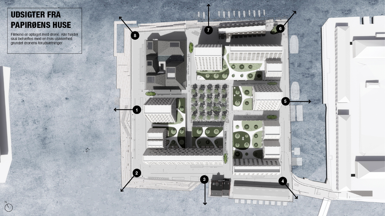
The films are shot with a drone. All heights must be encumbered with some uncertainty due to the drone's preconditions. Preliminary Illustrations. No content can be deemed exhaustive in the context of any form of property purchase, ownership or rental, or any contracts or other agreements associated with these.
GET A GLIMPSE OF THE VIEW
Click N, S, Ø, V on the map to see the drone film and views of Copenhagen Harbour.
Viewpoint 1
Viewpoint 2
Viewpoint 3
Viewpoint 4
Viewpoint 5
Viewpoint 6
Viewpoint 7
Viewpoint 8
The tallest building of THE PAPER ISLAND will be 41 meters, while the remaining building bodies will be approximately 30 meters high. The aquaculture house consists of several pyramid peaks that vary in height from between 24-30 meters.
UNIQUE NEIGHBOURHOOD
- SET IN NATURE
THE PAPER ISLAND’s neighbour to the north, The Opera Park, brings nature to the new neighbourhood’s door step.
The park is full of trees, ponds and pathways, lit up in the evenings and in overcast weather. Special outdoor experiences are remembered and re-enacted with future visits.
The plants and landscaping in The Opera Park, take on a different character in each of the four seasons.
The park’s nature is shaped according to six themes; The English Garden, The White Nordic Forest, The Red North American Forest, Oak Forest, The Cherry Grove and The Tropical Greenhouse.
Refshaleøen and Langelinje frame the view to the north, where incoming boats enter Copenhagen harbour at its widest point.
The Royal Academy of Architecture on Philip de Langes Allé is located just a stone’s throw away.
The Danish Navy occupied the adjacent area on Holmen until 1993. Today, outhouses, structures and small islands from the past bring a story to the island at every street corner.
Read more about The Opera Park at A.P. Møller og Hustru Chastine Mc-Kinney Møllers Fond til Almene Formål and the architect’s website; Cobe
Preliminary Illustrations: Cobe
SHORTCUT FROM PAST TO PRESENT
To the south is Christianshavn. Bustling with activity, and with past and present hand in hand. Closest to THE PAPER ISLAND is The Royal Greenland Dock. At one time the smell of dried fish, herring and leather floated through the air. Today, it is The Street Kitchen that keeps hunger at bay.
At a time when trading activities dominated the area, North Atlantic House was an important cultural centre, bearing a strong Nordic DNA.
Christianshavn’s rich character is built on a series of unique landmarks, streets and squares, and of course its canals. Iconic building’s include The Church Of Our Saviour with its twisting spire and Christians Church which ends the axis of Strandgade.
The unique location of THE PAPER ISLAND gradually becomes evident. The bicycle and pedestrian bridge link to Nyhaven, The Royal Theatre, Amalienborg, The Marble Church, Kongens Nytorv and Kongens Nytorv Metro Station.
Read more about Nordatlantens brygge – The North Atlantic House
Holmen
THE PAPER ISLAND’s boundary to the east faces The Naval Arsenal, Kuglegården which has been restored in immaculate detail. This can be seen at the entrance gateway, where the original ochre yellow has been restored to the facades. The Naval Arsenal is a living example of how a once closed military facility has been made freely accessible.
At one time, the only way to access Holmen was by boat – to Christiansholm. Then, from here, crossing a bridge to reach Arsenal Island and the Naval Arsenal complex. If you look closely, you can see the majestic King’s gate, built in 1742-46 and carrying a bust of Christian VI.
Water has also strongly influenced the architecture and daily activities to the east, where Kløvermarken, a vast open and recreational area is just a short bike ride away.
Read more about Kuglegården
MARITIME HISTORY CLOSE TO THE CENTRE
The bicycle and pedestrian bridge over the canal directs attention towards the west and to The Royal Theatre, Ofelia Square and connecting to quayside walks along oakwood planks. The traces of Maritime history and atmosphere are further enhanced by the bulky warehouses flanking the canal as it continues north.
The route from Copenhagen’s Harbour crosses one of the capital’s most prestigious areas, Frederiksstaden, passes through Saint Anne’s Square and meets the long, tree-lined boulevards of Bredgade, Amaliegade and Esplanaden. Rising from the city at this location are the almost imposing forms of The Marble Church and Amalienborg Palace.
Read about the architecture of Skuespilhuset ( The Royal Theatre)


